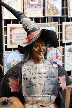
 Every year, from October 4th through 12th, the San Froilán Fiesta lights up Lugo, the capital city of Lugo province in Galicia, the northwest region of Spain. Famous bands perform onstage. Puppeteers and street musicians rim plazas or spill along side streets. Artisans sell handcrafts on blankets. A silver cowboy statue springs to life. A witch guards a major shop on a corner. Another witch peers out a window.
 Witches? Isn’t this festival about a saint (San Froilán)?
Like all of Galicia, Lugo is steeped in Celtic and Roman Catholic history. Founded by Celts and dedicated to Lugos, God of Light, Galicia boasts a belief in meigas, benevolent witches with curative powers who watch over the land. If you want a vacation to get into a Halloween mood, Lugo is the place to go.
The Romans brought Christianity to Galicia. The Roman wall encircling the old town is considered a national monument. Though wide enough to drive a car on, the wall is reserved for walking only. Inside its 10 arches, cobbled streets lead to several plazas and churches. One of these, the Convent and Church of St. Francis, houses the Provincial Museum showing Galician history and art.
 The St. Mary’s Cathedral (or Lugo Cathedral) became a pilgrimage center in the Middle Ages. A chapel is dedicated to San Froilán, patron saint of both Lugo and Leon provinces. A ninth-century hermit and later a bishop, San Froilán founded monasteries in the early days of the reconquista, or re-Christianizing, of Spain.
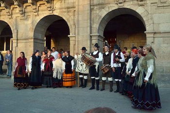
 The festival has three highlights: October 5th, the saint’s religious day; the following Sunday, dedicated to traditional Galician music and dance; and the eighth day, when plazas fill with a Medieval Fair.
The first visit my husband and I took coincided with the Medieval Fair. Artisans displayed traditional black pottery. Performers exhibited jousting and archery skills, and reenacted historical scenes. Stalls offered mead, honey, and pulpo (octopus). A falconer stood near his array of raptors -- falcons, hawks, eagles, and horned owls. In the evening, we were treated to a glittering acrobat show in the Plaza Mayor. And around 2:00 a.m., we watched a spectacular fireworks display from our hotel window.
On our most recent visit to Galicia (October 2012), we purposely went on the Sunday that celebrates traditional culture. Once unpacked, we headed out to stroll the plazas and browse various entertainments. On a side street, a man drew in crowds with his one-man band. Andean fusion music floated from one corner of the Plaza Mayor. Near the ayuntamiento (town hall), dancing groups performed folk dances. Little statues and dolls dressed like witches reminded us of Lugo’s (and Galicia’s) rich folklore.
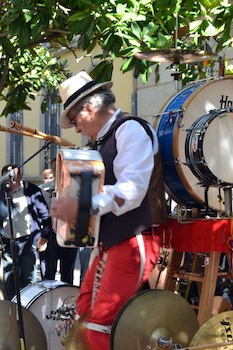 After lunch, we came upon a band rehearsing at the Plaza Santa Maria, playing Galician music with traditional instruments -- four harps, four Galician-style bagpipes (gaitos), four violins, six tambourines, one huge set of drums and a smaller drum, and about eight “lap” organs with handles, as well as castanets and a mouth instrument “twanged” by hand. The music sometimes sounded Irish, sometimes Greek, sometimes Spanish -- and always haunting. That night, we heard the concert all over again, with the orchestra members dressed in style.
The day was topped off in the Plaza Mayor at a table outside one of the many cafés, where we sat until nearly midnight enjoying the dancing crowd and the orchestra onstage. The following morning, we indulged in a slice of Tarta de Santiago (a traditional Galician almond cake).
Like the almond tang of the cake, the San Froilán Fiesta lingers in our memories.
An interesting day trip 11 miles from Lugo:
Museo Arqueolóxico do Castro de Viladonga
27259 Castro de Rei
Lugo (province), Galicia
+34 982314255
museo.viladonga@xunta.es
Restaurants we enjoyed:
A Nosa Terra
San Eufrasio, 171
27295 Lugo, Spain
+34 982250834
A Tasca
Cruz, 3
24001 Lugo, Spain
982228718
A good hotel near the Plaza Mayor:
Hotel Méndez Núñez
Rua de Reiña 1
27001, Lugo, Galicia, Spain
1-866-599-6674
If you would like to purchase this article for your publication, please click here to contact the author directly.
]]>
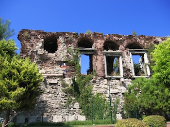 Just as I was on the verge of giving up, I rounded a bend on the coast road and suddenly there it was. This crumbled section of old wall would be as unremarkable as any other were it not for the three huge windows still in place in a recess of the masonry. In their heyday they would have looked out across the Great Palace’s private harbor, protected by two huge lion sculptures which can now be seen in the Archaeological Museum. A few remaining corbels of a long balcony, too, can still be seen at ground level.
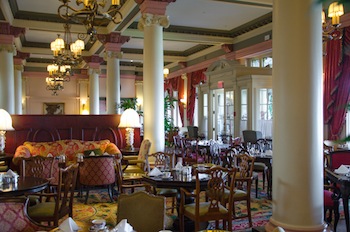 Have you ever wanted to partake in an experience where you would be tended to like royalty? Would you like to take a seat at an Edwardian-style tea party where delicately prepared menu choices are served on magnificently painted fine china and staff members provide the utmost in superb personal service? The illustrious and classical Fairmont Empress Hotel in Victoria, British Columbia, offers these delights in an Afternoon Tea that is truly fit for a king or queen.
 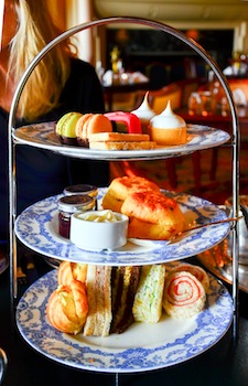 One of the most notable features is the graciousness of the staff. Even though they serve hundreds of guests each day, they move flawlessly about the room as if rehearsed to ensure that each guest is pampered and comfortable. They serve an array of delicate tea sandwiches, croissants, scones, meringues, and berries with cream that are almost too beautiful to eat. However, each morsel is tastefully delicious!
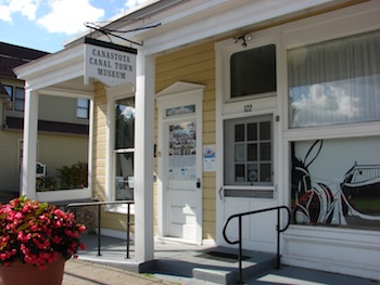 3. Canastota Canal Town Museum: All along the canal towns grew up. The small town of Canastota strives to preserve its canal town ambiance. Canal Town Museum, in a former bakery, is now home to the museum. It is one of the oldest structures on Canal Street, displaying canal memorabilia, a replica of a canal boat cabin, and exhibits about local businesses that served the canalers.
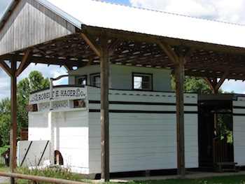 4. Chittenango Landing Canal Boat Museum: Check out the three-bay dry dock where Erie Canal boats were built and repaired. The on-site interpretive center and library provides hands-on activities and exhibits. There is also a sunken canal boat, blacksmith shop, sawmill, stable, warehouse, and woodworking shop.
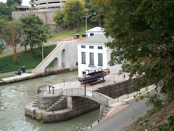 8. Lockport: Next to Locks 34 and 35 is the Flight of Five Locks, considered an engineering marvel when it was built. Located at the bottom between the two sets of locks is a small museum. Above the locks visit the Erie Canal Discovery Center, a state-of-the-art interpretive center, to learn about the role the canal played in the history of New York State.
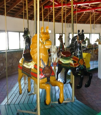 The carousel is a unique and historic antique. Remarkably, it has been operating in the same location for eighty-one years, delighting children young and old. Owned by the city and registered with the Smithsonian Institution, it is truly a Texas treasure.
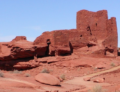 From Flagstaff head to the northeast on Highway 89 and visit Wupatki and Sunset Crater Volcano National Monuments. These two parks share a 35-mile loop road branching off Highway 89, circling through the parks, and rejoining 89. The contrast between parks is significant and the link between them is unusual. Sunset Crater is dedicated to a spectacular act of nature, the eruption of Sunset Volcano in 1064-65, while Wupatki chronicles the ancient people who occupied the nearby area during roughly the same period. The cinder cone of Sunset and impressive lava flows tend to make you feel as if you have stepped into a moonscape. Then you walk through the Wupatki pueblo and it is hard to imagine how the Sinagua people who occupied this arid landscape survived, although the silent remains stand as a testament to their ingenuity. Questions abound concerning their lives and why they essentially disappeared from this area when they did.
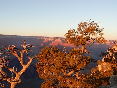 Yavapai Point is the perfect place to go and sit on the rim to watch the sun set over the Canyon. We followed the sunset with a dinner at the El Tovar, the historical showpiece hotel of the Village. The service was magnificent, truly attentive without hovering or being intrusive, and the food exceptionally good. I would recommend the Grand Canyon chardonnay as a nice accompaniment to dinner. After dinner, we ventured back out to Yavapai Point to see the most incredible sky full of stars imaginable. One of our group commented, “This rivals the Grand Canyon.” With no man-made lights anywhere near, the vastness and visibility were superb.
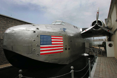 Today you can relive the era at the Foynes Flying Boat Museum at the actual site of the original terminal, located 21 miles west of Limerick city in Ireland. This was the European center of transatlantic civil aviation up to 1945, and an important strategic site during the years of World War II.
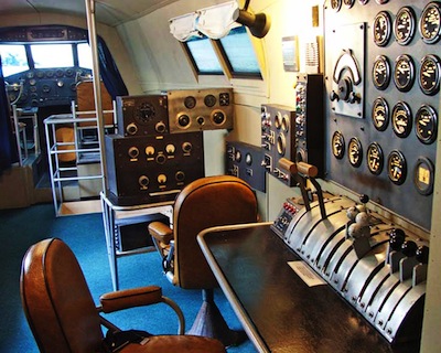 You can step on board a splendid replica, which was meticulously rebuilt from drawings supplied by The Boeing Company, and sit in the captain’s chair as you reach for the throttle and check the dials.
 There seems to be an interesting trend starting in the theatre world, one which has history lovers and travel addicts like me very, very intrigued.
  The restaurant is located about a half-mile block north of the Stalin Park Promenade (yes, they named a park after him) on the city pedestrian mall. You enter the medium-lit soft yellow dining room and encounter a subdued European bistro that you would expect to see in Rouen rather than in a garish Asian city like Harbin. Above a well-tended fireplace and mantel you will notice a large, painted, Mona Lisa-like smiling portrait of Lucia in her youth, done just about the time the original building was her family home. On an opposite wall, resplendent in Czarist uniform with too many medals and wearing a great muttonchop beard, is the Russian general who was also the founder of the Harbin Institute of Technology, today one of China’s leading universities. In addition, photos of the early 20th century Russian Orthodox and Russian Jewish communities are displayed, including those of the great 1932 Sonjiang River flood and the surprisingly efficient rescue efforts during the same. FEMA could take note of the cooperative spirit of both communities. Balalaikas, religious icons, and photos of prominent business and professional people of the era abound.
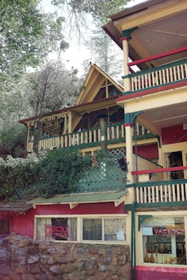 Built in 1895, this former miners’ boarding house experienced periods of activity comingled with quiet abandonment. When Rick Brown, a newly-minted U.S. citizen from New Zealand, purchased the inn in 2009, he knew it would be a labor of love. His work continues and his love for the inn shows.
 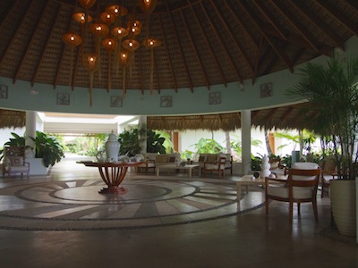 A rotund lobby with an intricate mosaic stone floor makes for an impressive entrance to Sublime Samana Hotel & Residence, a two-story, horseshoe-shaped building with palm trees, exotic shrubs, and flowering plants scattered along a well-watered lawn from which a paved pathway leads to a private beach two hundred yards away.
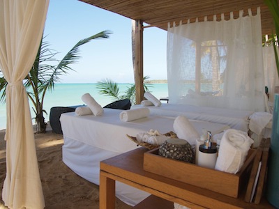 After an enjoyable massage under the fluttering curtains of a canopy, I was delighted to be handed chilled milk straight from a coconut.
 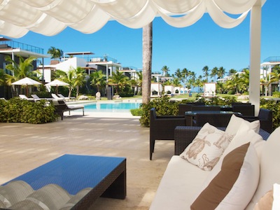 Breakfast can be taken either in the Bistro restaurant on the ground floor beside the lawn or, more interestingly, adjacent to it, outside, on a small terrace shaded from the sun by white curtains and large exotic plants. The menu is a balanced one, including healthy options of fruit, yogurt, and cereal as well as more substantial items such as pancakes, ham, cheeses, omelets, breads, and pastries. Two of the hot choices represent classic local flavor: Mangu of Samana, a traditional dish of mashed, boiled plantain served with fried eggs, caramelized red onion, coconut, cheese, and sausage, and eggs ranchero, fried eggs served with fried corn tortillas, tomato chili sauce, and guacamole. So replenished were we after trying them, we did not require lunch. The other must-have is the coffee -- strong, dark, and Dominican, brewed strongly.
 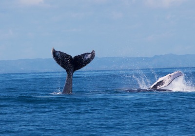 While Sublime Samana provides enough diverse activities for an enjoyable stay, short excursions are possible. There are bars and restaurants in Las Terrenas. Also available are leisurely boat trips such as those organized by Tour Samana With Terry to see the humpback whales that arrive in Samana to mate, give birth, and nurse their young. Other choices include a visit to the island of Cayo Levantado or to the Los Haitises National Park with its calcified hills, caves, mangroves, sea turtles, and a variety of bird species.
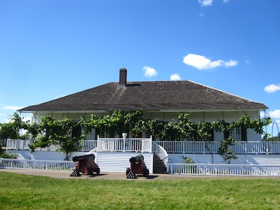 Ting! Ting! Ting! It’s hot and dark. Hard to breathe. The enormous fire illuminates the blacksmith’s concentrated, sweating brow. He hammers a red-hot piece of iron into a new pot hook for the kitchen. The other blacksmith tugs at a lever to operate the billows -- which is about the size of a refrigerator, if there had been such things as refrigerators -- and the fire roars.
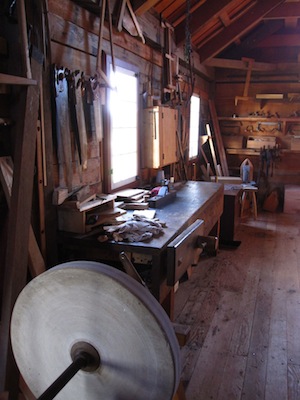 Outside the stockade, it’s 2013. This is now Washington State. Oregon became its own state, just across the nearby Columbia River. And the original Vancouverites, upset at the new U.S. border and all that it entailed, packed up and headed north to start a new Vancouver.
 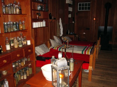 Tool around in the Woodshop. Double-check the books at the Counting House. Go to Jail. See what’s in all those little glass bottles in the Infirmary.
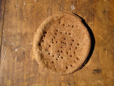 Before you leave the early 19th century, head over to the turret at the northwest corner of the Fort. It’s not always open, but if it is, you can take the stairs to the second level and peer out in every direction at the brave new world beyond. Your world.
 It’s 2 p.m., the sun is shining at full blaze, and I’m ready for a rest. Sitting by the market I look across the square to its grand skyscrapers hovering above -- the scene is intriguing. To the left elderly men challenge each other to a game of chess. On the right a clown draws a crowd of kids with his juggling. Everywhere people sit soaking up the sun, reading books, and chatting to friends.
 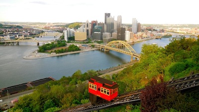 In contrast to the city, the natural boundaries of the Allegheny and Monongahela Rivers create the downtown “triangle.” Point State Park marks the tip of it. Here the meeting of both rivers forms the Ohio River. Skyscrapers behind you, your view extends far beyond the riverbanks to the lush green hillsides of Pittsburgh. Here you can breathe, relax, and hear the rivers’ rushing waters pass beside you.
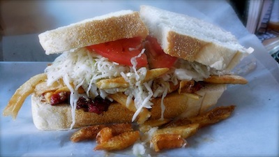 Back at Market Square, at Primanti Brothers, this time the realization kicks in that this is America. Where else could you find a ham and cheese sandwich filled with coleslaw and chips while slurping a bottomless Diet Coke? I’ve seen enough of downtown to wish I had more time to discover all of Andy Warhol’s hometown -- including the Strip District with its ethnic culinary melting pot and Southside’s nightlife scene. The city caught my attention and I will return someday soon.